Early African Kingdoms: Lesson Plan
NCSS (National Council for the Social Studies) Thematic Standard: III People, Places, and Environment.
Vocabulary Words:
plateau-flat, raised ground.
savannas-grasslands without trees.
Bantu Migration-the eastward movement of peoples from thr Bantu language group.
Lesson Outline:
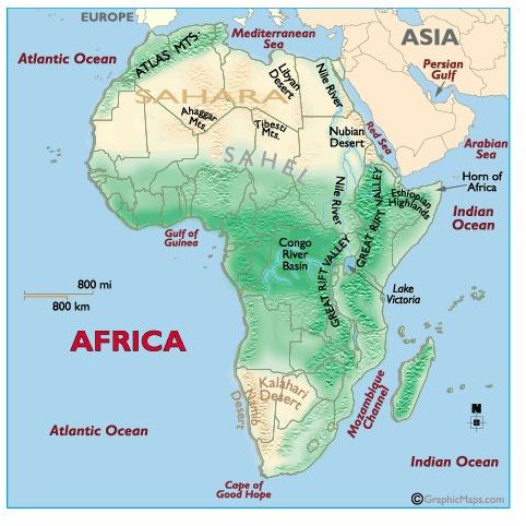
First, have your students examine the geography of the continent. Use the Facts About The Continent of Africa Handout below to review the basics.
Facts About The Continent of Africa Handout
The world’s second largest continent, Africa is three times as large as the United States. The continent’s geography is varied, containing both lush rain forests, arid deserts, expansive grasslands, and coastal beaches. Of course, its geography has impacted the settlement of its people.
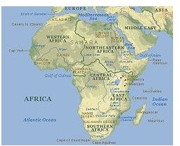
Africa has five regions: West Africa, East Africa, North Africa, Central Africa, and Southern Africa.
- West Africa: The geography in this area ranges from rainforests to desert. The area includes part of the Sahara Desert.
- East Africa: The Great Rift Valley descends from the Sahel. It is 40 miles wide, 2000 feet deep and 3000 miles long beginning at the Red Sea and ending in Southern Africa. To the east of the valley is Africa’s tallest mountain, Mount Kilimanjaro, and Mount Kenya.
- North Africa: This region is made up of the coastal area and an inland area. The northern coastal area sits on the Mediterranean and has a mild climate with a large amount of rain. Inland and south, lays the Sahara which is the largest desert on earth. The Sahara covers about 3500 miles. A large plateau known as The Sahel is south of the Sahara and is covered by grassland or savannas.
- Central Africa: Verdant tropical rain forests with hot and humid weather occupy this area near the equator. South of the forests, the land becomes another desert, the Kalahari. The Congo River (previously known as Zaire) runs through Central Africa.
- Southern Africa: This area is mostly productive highland.
Next, discuss Early African kingdoms:
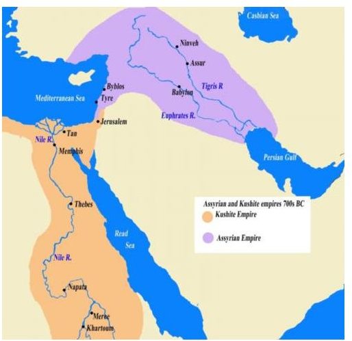
- Nubia – around 3000 BC in the southern Nile Valley. .The Nubians were skilled warriors who used bows and arrows and interacted greatly with the Egyptians to the north. Nubians and Egyptians shared similar customs and political systems.
- Kush-By 2000 BC Nubia had become Kush. The people of Kush developed a vibrant trade in goods from the interior (elephant tusks, gold, timber) along the river’s caravan crossings. The two most prominent cities were Napata and Meroe.. The Kush were ruled by the Egyptians for approximately 500 years. In or about 1000 BC, King Piankhi of Kush threw off Egypt’s dominance and both kingdoms were governed by Kushite kings. The capital was Napata.
- Egypt was invaded by the Assyrians in 671 BC and drove the Kushites back to the turn of the Nile River, their native soil. The Kushites learned iron making from their conquerors and used this skill to make their new capital, Meroe, a significant iron production center. The merchants of Kush traded iron, ebony, and leopard skins to trade with societies from the Red Sea and Mediterranean regions. They also traded with people from the areas near the Indian Ocean. Meroe’s wealth enabled it to build extravagant homes around central courtyards and public baths similar those in Rome. The Kush survived for around 150 more years until a kingdom from the area by the Red Sea, Axum, invaded and defeated them.
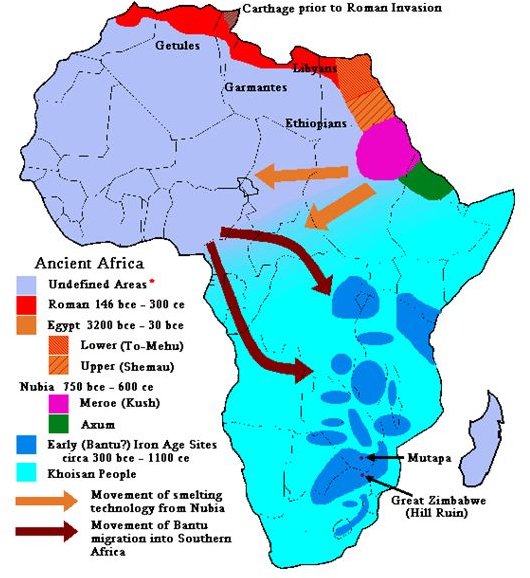
- Axum-(700 - 200 BC), a trading power that dealt with India, Egypt, Greece, Rome, and Persia. Axum’s primary port was at the city of Adulis where the citizens of Axum traded ivory for goods such as olive oil, cotton, and copper. Axum adopted many Roman ways, including Christianity. King Ezana made Christianity Axum’s official religion in 330AD. The spread of Islam would see the end of Axum in 7th century, and its rulers would form a Christian kingdom, Ethiopia.
- The Nok-a West African culture that expanded in the Niger And Benue river valleys. Archeological evidence has revealed the Nok produced metal and worked their farms with iron hoes, making farming more productive. Successful farming increased population and used up the fertile land. A thousand year migration eastward began that is now referred to as the Bantu Migration a descendants of these settlers speak languages with Bantu components.
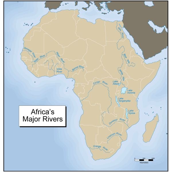
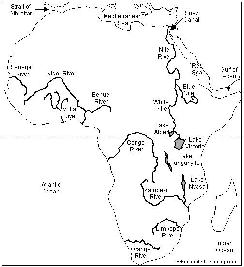
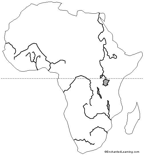
Using the reference maps below, have the students label the locations of the Kush, Nubian, Assyrian, Axum, and Nok kingdoms on the blank outline map. They should also label the Red Sea, Mediterranean, Nile River, Niger River, Benue River, and the Congo River. Students should answer the following for each culture.
- What natural features made this location suitable for settlement?
- What elements enhanced or hindered trade? Explain your answer.
- Which geographical features made them vulnerable to attack? Which provided protection?
Extension Activities:
Have students research the following:
- How tall is Mount Kilimanjaro and in what country is it?
- What event caused King Ezana of Axum to convert to Christianity?
- Investigate the various patterns the Bantu Migrations followed?
Reference and Outline Maps
Map Credits
- https://www.woodlands-junior.kent.sch.uk/Homework/rivers/nile.htm ?
- https://www.ancientsudan.org/history_07_assyro_map.html
- https://exploringafrica.matrix.msu.edu/students/curriculum/m6/activity2.php
- https://www.enchantedlearning.com
- https://www.worldatlas.com/webimage/countrys/aflnd.htm
- https://www.empathosnationenterprises.com/Consulate/EN-Library/Black-Studies/afancient.html
This post is part of the series: World History in a Year (or 10 months) Part 3
A series of lesson plans for a world history curriculum. This series is a continuation of two other collections of world history lesson plans.
- Republic to Empire: The History of Ancient Rome
- Assignments and Interactive Activities on The Roman Empire
- Webquests on Julius Caesar
- A Quest to Find World War One
- Early Africa and Its Kingdoms
Search
Categories
- Advice for parents of teens (42)
- Chinese lesson plans for secondary grades 6 12 (25)
- Classroom management tips methodologies (125)
- Education industry news opinion (39)
- English lesson plans for middle school (358)
- Esl lesson plans for all grade levels (161)
- Esl teaching tips strategies for any grade level (137)
- French lesson plans for secondary grades 6 12 (49)
- Fun activities crafts for grade school (397)
- Fun learning ideas for toddlers (184)
- German language study guides tips (40)
- German lesson plans for secondary grades 6 12 (21)
- Great ideas for science fair projects (69)
- Help with english grammar vocabulary (121)
- Help with geography homework (35)
- Help with learning japanese study guides speaking tips (47)
- Help with learning to write and speak chinese (55)
- Help with math homework (118)
- Help with writing assignments paragraphs essays outlines more (125)
- High school english lesson plans grades 9 12 (570)
- High school history lesson plans grades 9 12 (86)
- History facts study sheets homework help (245)
- Homeschool regulations legal issues (24)
- Homeschool socialization ideas activities (22)
- Homeschool teaching techniques tips (99)
- Homeschooling methodologies (37)
- Inclusion strategies for mainstreamed classrooms (288)
- Italian language study guides (21)
- Italian lesson plans for secondary grades 6 12 (23)
- Japanese lesson plans for secondary grades 6 12 (17)
- Keeping homeschool records (10)
- Learning french study guides speaking tips (59)
- Lesson plans for high school math grades 9 12 (18)
- Lesson plans for high school science (37)
- Lesson plans for middle school math (99)
- Lesson plans for middle school science (131)
- Lesson plans for middle school social studies (66)
- Lesson plans for pre k and k (402)
- Lesson plans worksheets for grades 1 amp 2 (440)
- Lesson plans worksheets for grades 3 to 5 (640)
- Literature study guides and chapter summaries (518)
- Middle school teaching strategies (76)
- Miscellaneous language lessons (10)
- Miscellaneous languages (108)
- Parenting a special education student (83)
- Parenting grade school aged kids (167)
- Parenting preschoolers toddlers (91)
- Parenting preteens tweens (30)
- Preschool crafts and activities for hands on learning (687)
- Preschool lesson plans worksheets themes for year round learning (460)
- Preschool teaching strategies advice tips (280)
- Science facts homework help (244)
- Secular non secular homeschool curriculum reviews (108)
- Social studies help cultures governments more (209)
- Software reviews second language acquisition ideas (66)
- Spanish language guides study tips (239)
- Spanish lesson plans for secondary grades 6 12 (196)
- Special education law idea ieps 504s cses planning (95)
- Student assessment tools principles (75)
- Study learning tips for parents amp students (74)
- Summer learning (79)
- Summer reading lists for grades k 12 (31)
- Teaching methods tips strategies (418)
- Teaching middle school history (84)
- Teaching students with emotional behavioral disorders (57)
- Teaching students with hearing impairments (25)
- Teaching students with learning disabilities (89)
- Teaching students with neurological disorders (125)
- Teaching students with physical disabilities (51)
- Teaching students with speech disorders (14)
- Teaching students with visual impairments (35)
- Teaching tips for foreign language instructors (40)
- Test taking techniques for all grades ages (30)
- The arts in high school (48)
- The arts in middle school (88)
- Tips for effectively teaching high school students (72)
- Tips for learning translating latin (107)
- Tips strategies for summer school teachers (15)
- Tips strategies for teaching grade school (237)
- Tips strategies for teaching the gifted student (84)
- Understanding infant development learning (71)
